GLWD
Global lakes and wetlands database
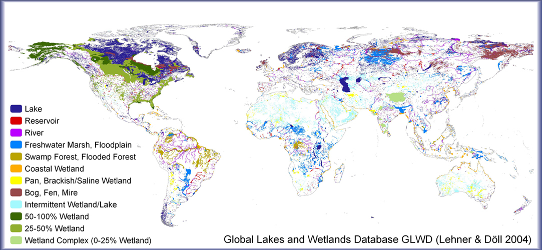
Drawing upon a variety of existing maps, data and information, a new Global Lakes and Wetlands Database (GLWD) has been created. The combination of best available sources for lakes and wetlands on a global scale (1:1 to 1:3 million resolution), and the application of Geographic Information System (GIS) functionality enabled the generation of a database which focuses in three coordinated levels on (1) large lakes and reservoirs, (2) smaller water bodies, and (3) wetlands. Level 1 comprises the shoreline polygons of the 3067 largest lakes (surface area >=50 km2) and 654 largest reservoirs (storage capacity >=0.5 km3) worldwide, and offers extensive attribute data. Level 2 contains the shoreline polygons of approx. 250,000 smaller lakes, reservoirs and rivers (surface area $0.1 km2), excluding all water bodies of level 1. Finally, level 3 represents lakes, reservoirs, rivers, and different wetland types in the form of a global raster map at 30-second resolution, including all water bodies of levels 1 and 2.
Related publications
Lehner, B., Döll, P.: Development and validation of a global database of lakes, reservoirs and wetlands, Journal of Hydrology, Volume 296, Issues 1–4, 20 August 2004, Pages 1-22, http://dx.doi.org/10.1016/j.jhydrol.2004.03.028.
Data
All GLWD data is available from the WWF website.
Project contact
For more information on this project contact Dr. Bernhard Lehner