GloRiC
Global River Classification
The growing pressure on freshwater resources and aquatic ecosystems mandates for advancements in sustainable watershed management; for example, new frameworks of environmental flow requirements such as ELOHA are promoted as means of improving ecosystem resilience. These new and advanced methods require manageable freshwater units to be applied, preferably accompanied with attributes that allow for stratified grouping or classification. Such units have previously been created on watershed and country levels, but a global classification at high spatial resolution is not yet available. The Global River Classification (GloRIC) project aims to create such units based on the analysis of geo-physical characteristics of river reaches at the global scale. Physical and climatic variables such as slope and temperature, as well as hydrological data that express characteristics of the flow regime are used to distinguish different river types. The spatially detailed and explicit global assessment is facilitated by the digital river network of the HydroSHEDS database at 500m pixel resolution.
To integrate the multiple aspects of river systems, a conceptual framework called ‘Global River Classification’ or GloRiC was develop based on current literature. The framework is divided in multiple sub-classifications that can be combine to create river reach types based on the goals of the project.
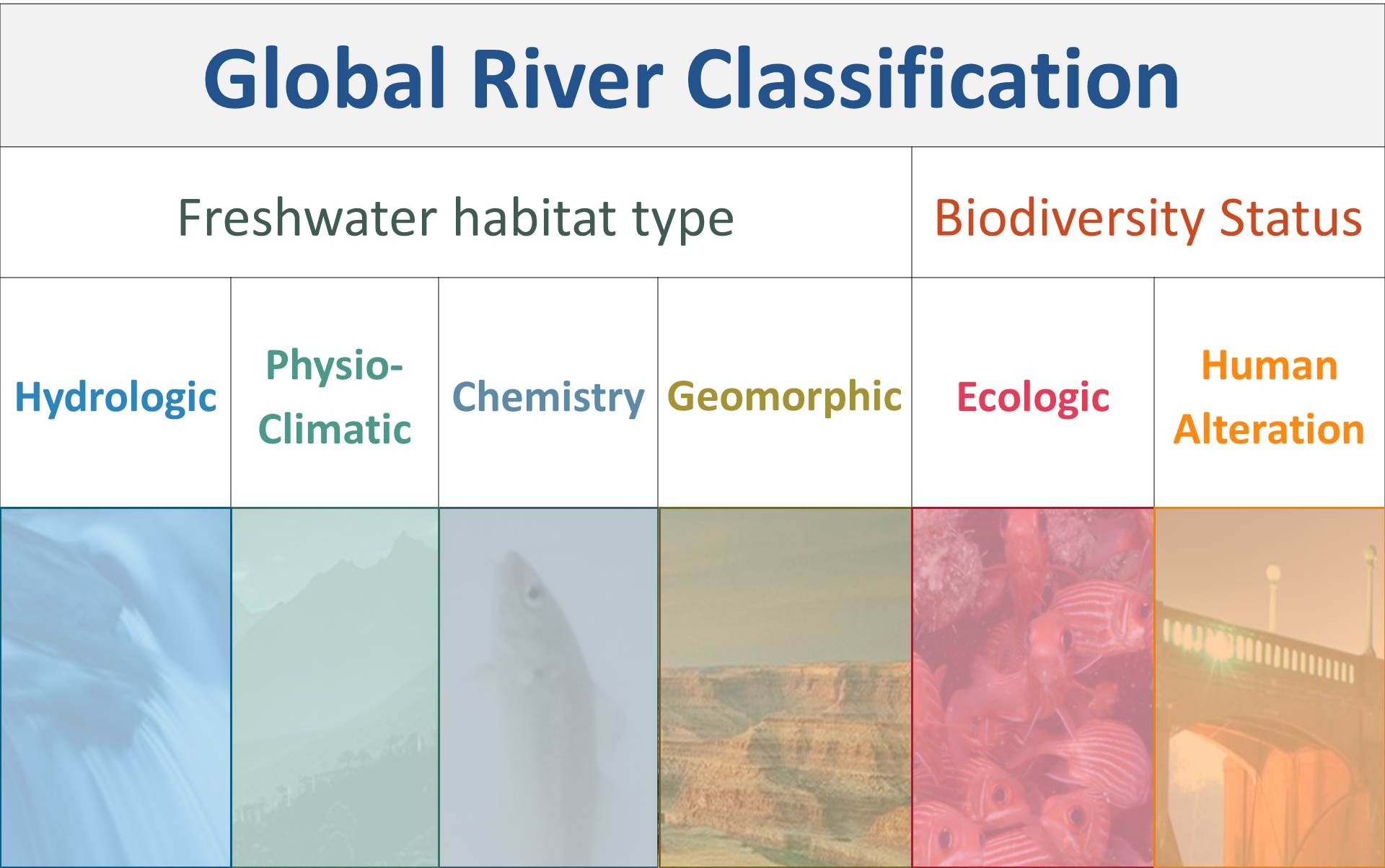
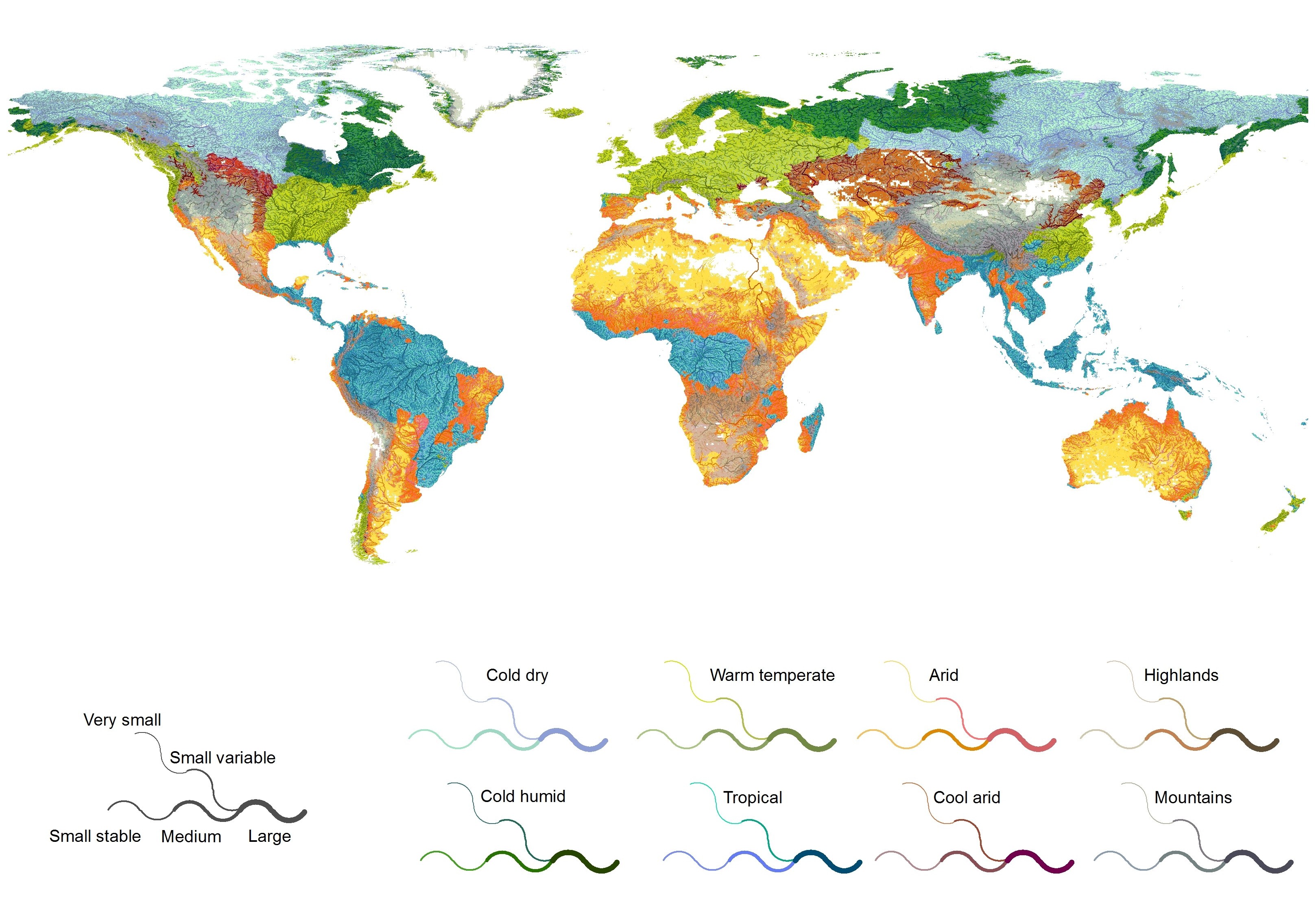
RiverTYPES is the first application of the GloRiC framework at the global scale. River reaches from the HydroSHEDS network at the 500m resolution were used as the basis of this datasets. RiverTYPES relies on geo-physical characteristics available at the global scale. Specifically, sub-classifications for Hydrology, Phyiography and Climate, and Geomorphology were derived using k-mean clustering. The resulting sub-classes were merged using statistically similarity to create a final river type for all of the 24 millions of rivers around the world.
Related Publications
Lehner, B., Verdin, K., Jarvis, A. (2008): New global hydrograhy derived from spaceborne elevation data. Eos, Transactions, AGU, 89(10): 93-94.
Ouellet Dallaire, C., Lehner, B., Sayre, R., Thieme, M. (2019): A multidisciplinary framework to derive global river reach classifications at high spatial resolution. Environmental Research Letters 14(2): 024003. doi: 10.1088/1748-9326/aad8e9
Related presentation
Lehner and C. Ouellet Dallaire. 2014. “River reach classification for the Greater Mekong region”. Oral presentation for international conference on the status and future of the World’s Large Rivers. Manaus, Brazil. July 21-25. (WWF consultant work)
C.Ouellet Dallaire and B.Lehner. 2014. “Multi-disciplinary geophysical classification of Canadian river reaches at high spatial resolution”. Oral presentation for national conference of NSERC Canadian Network for Aquatic Ecosystem Services. Montreal, Canada. April 30- May 2. (PhD work)
Ouellet Dallaire and B. Lehner. 2011. “Development and evaluation of a global river reach at high spatial resolution”. Oral presentation for international conference on the status and future of the World’s Large Rivers. Vienna, Austria. April 11-14. (Master work)
Ouellet Dallaire and B.Lehner. 2011. “Global River classification (GloRiC): a multi-disciplinary framework to classify river at high spatial resolution for large-scale studies”. Poster presented at institutional conference the Sustainability Research Symposium, Montreal, Canada, March 4th. (Master work)
Project contact
For more information on this project contact Camille O.Dallaire.